Urban Flooding Task Force
What is the problem/challenge?
Cities are particularly vulnerable to flooding. Their dense development can result in the exposure of large populations, critical infrastructure, and valuable assets – even when flooding occurs over relatively small spatial scales. They face hazards from a variety of flooding types, including coastal, fluvial (river/overbank), pluvial (rainfall), and groundwater flooding, along with flooding that results directly from the failure of urban water management infrastructure. All of these hazards are augmented by conventional patterns of urban development, which typically involve large areas of impervious cover, and will be amplified by climate change in the coming decades. As existing flood management programs such as the US National Flood Insurance Program and the US Army Corps of Engineer’s flood mitigation infrastructure projects are very limited in their consideration of urban flood hazards, urban areas are particularly sensitive to flooding when it occurs.
What have we been doing to address the problem/challenge?
The Urban Flooding Task Force has investigated the interconnected social-ecological-technological systems (SETS) components of flood risk in cities across the UREx network. We have also conducted research on the knowledge systems being developed to help cities enhance their resilience to extreme weather events that result in flooding. Our research includes the following:
- Synthesizing existing research to evaluate pluvial (rainfall-driven) and groundwater flooding – urban flooding hazards that have previously received limited attention
- Engaging practitioners and reviewing plans to compare the knowledge systems used by cities to enhance their resilience to extreme weather events that can cause flooding
- Investigating historic urban landscape transformations and how their legacy impacts current and future flood risk
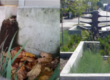
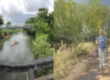
- Conducting experiments to evaluate green infrastructure performance in managing urban flooding, and to explore the means to improve performance through design
- Analyses of weather, climate and terrain data in UREx SRN cities
- Conducting coupled hydraulic and hydrologic modeling of urban flooding in cities where sufficient data are available
What have we found?
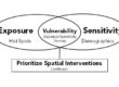
- The risks and uncertainties faced by urban infrastructure are becoming so great due to climate change that the ‘fail-safe’ paradigm should be questioned. As an alternative, UREx researchers have developed a framework to assess potential flooding solutions based on multiple infrastructure resilience characteristics using a multi-criteria decision analysis (MCDA) analytic hierarchy process algorithm to prioritize ‘safe-to-fail’ and ‘fail-safe’ strategies depending on stakeholder preferences (Kim et al., 2017).
- Communication amongst individuals, social groupings, and formal organizations will continue to be an essential aspect of flood mitigation in response to extreme weather events (Zimmerman, 2017).
- The continuously increasing number of comprehensive approaches to urban flood risk assessment offers evidence for a paradigm shift towards a more inclusive way to understand multi-dimensional aspects of urban flood vulnerability across disciplines and different knowledge systems (Cho and Chang, 2017).
- Although there have been recent advances in approaches to assess the risk presented pluvial flooding and to enhance the resilience of cities to its impacts, they have not yet been broadly implemented (Rosenzweig et al. 2018).
- Cloudburst events are short-duration, high-intensity rainfall events. Only two UREx cities (New York City and Phoenix) currently consider cloudbursts in their flood management plans. However, partnerships between cities can be a particularly important component in planning for cloudbursts and present opportunities for cities that have not yet begun planning for this type of extreme weather (Rosenzweig et al., 2019).
- In Portland, the highest frequency of citizen-reported flooding is associated with relatively small (<50mm) rain events (Michelsen and Chang, 2019). High temporal resolution precipitation data is superior for climate trend detection compared to daily data (Cooley and Chang, 2016). Combined sewer pipe density, green space, impervious surface, population density, and percentage of the population without higher education are associated with 69% of the variation in combined Topographic Wetness Index and Urban Heat Index (Fahy et al., 2019).
- Historical land use can play an important role in understanding urban floods (Bae and Chang, 2019).
- A sample of green infrastructure projects in the U.S. revealed a variety of actually implemented and potential financing mechanisms to support green infrastructure, though better data is needed to expand knowledge about such mechanisms for adoption and communication (Zimmerman, Brenner, Llopis Abella 2019). How green infrastructure is integrated with “gray” infrastructure is also an important issue (Zimmerman, Grimm and Brawley-Chesworth 2020).
Where are we going?
Our work to date has identified opportunities for future research that can be used to support the development of enhanced urban flood resilience. As we move forward, our research will focus on developing more robust techniques for flood hazard mapping in dense cities and developing landscape-scale strategies for urban flood mitigation during extreme events.